


Best Value
Overlay Creator Access
7.99
Every month
Create unlimited aviation overlays with Overflight’s desktop app for $7.99/month. Seamlessly export to ForeFlight and Garmin Pilot for fast, precise planning anywhere.
Valid until canceled
ANY active Overflight subscription will provide user access
Explore App Features
Click the Phone to Explore the Function

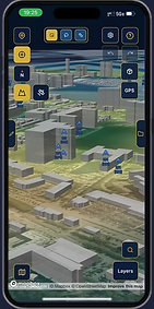





Map Layer Interface
3D Analysis
Colorized Terrain


Intuitive Overlay Creation & Editing
Visuallized Satellite Prediction
Content Package Export System


Create Digital Map Layers
File Storage & Export System
Upload Custom Plates to Foreflight


User Waypoint GPS Export System
Overflight Search/Mass Waypoint Import
Convert Paths to Programmable Flight Plans
Map Layer Interface
Overflight’s Map Layer Interface gives pilots control over the geographic and aviation information displayed while planning and creating overlays. Users can choose between multiple base maps, including traditional mapping and satellite imagery. Integrated FAA VFR Sectional, & IFR Low, and IFR High charts can be layered over the map with independently adjustable opacity, allowing aeronautical information to be blended with underlying imagery and terrain. Overflight’s integrated airport database displays aviation facilities directly on the map and visually distinguishes controlled, uncontrolled, and unknown tower-status airports as well as heliports and Seaports. Together, these tools create a customizable mapping environment tailored to each pilot’s planning needs.
Primary Data Sources:
-
Mapbox — provides online satellite imagery and the Streets, Outdoors, Light, Dark, and Navigation basemap styles.
-
OpenStreetMap (OSM), distributed by Geofabrik — provides roads, waterways, settlements, land-use features, and other geographic information used to build downloadable offline basemaps.
-
Copernicus Sentinel-2 — provides satellite imagery used to build downloadable offline satellite layers.
-
Mapbox Terrain DEM / Terrain-RGB — provides online elevation data used for terrain visualization.
-
USGS 3D Elevation Program (3DEP), through The National Map — provides elevation data used to build downloadable offline terrain layers.
-
FAA Digital Aeronautical Charts — provides chart imagery for supported VFR Sectional, VFR Terminal Area (TAC), IFR Enroute Low, and IFR Enroute High map layers.
-
FAA Digital Obstacle File (DOF) — provides obstacle locations and height information displayed through Overflight’s obstacle layer.
-
OurAirports airports.csv — provides worldwide airport names, identifiers, locations, facility types, and elevation information used by Overflight’s airport layer.
-
OurAirports runways.csv — provides runway locations, dimensions, surfaces, and other published runway information.
-
FAA National Airspace System Resources (NASR) APT.txt — supplements U.S. airport information, including FAA airport data and control-tower status.
3D Analysis
Overflight’s 3D Analysis transforms traditional flight planning into an interactive three-dimensional environment. Pilots can visualize terrain, elevation changes, routes, waypoints, paths, polygons, and custom overlays in their real-world geographic context. At higher zoom levels, Overflight also displays 3D buildings and manmade structures, allowing pilots to visualize the built environment and better understand how structures relate to planned routes and operating areas, particularly in complex urban environments. Combined with Terrainosaurus terrain analysis, FAA charts, obstacles, and satellite imagery, 3D mode helps pilots evaluate ridgelines, valleys, mountain passes, confined areas, urban environments, and potential terrain or structural conflicts from multiple viewing angles, providing a more intuitive perspective for preflight planning.
Primary data sources:
-
Mapbox Terrain-RGB elevation data — supplies the digital elevation information used to construct and visualize the three-dimensional terrain surface.
-
Mapbox mapping/rendering environment — renders terrain and other geographic information within Overflight’s interactive 3D environment.
-
Supported building and structure geometry — provides 3D representations of buildings and manmade structures at supported zoom levels, helping pilots visualize the built environment during urban and low-altitude planning.
-
FAA Digital Obstacle File (DOF) data — provides information on known obstacles such as towers, antennas, and other vertical structures. Overflight displays this obstacle information within the 3D environment to help pilots understand the relationship between published obstacles, surrounding terrain, and planned operations.
-
Overflight project data — user-created waypoints, paths, polygons, routes, and other custom overlays are positioned within the 3D environment.
-
FAA and Overflight aviation layers — additional aviation information can be displayed alongside terrain, structures, obstacles, and user-created content.
Together, these sources allow Overflight to combine terrain elevation, 3D buildings and structures, FAA obstacle information, aviation data, and user-created overlays within a single interactive three-dimensional planning environment.
Colorized Terrain
Overflight’s Colorized Terrain, powered by Terrainosaurus, helps pilots quickly visualize terrain relative to a selected flight altitude. Terrain is dynamically highlighted using progressive warning bands: red within 100 feet below the selected altitude, orange within 500 feet, and yellow within 1,000 feet. Pilots can adjust altitude and layer opacity to evaluate different flight scenarios and identify ridgelines, mountain passes, valleys, and areas of reduced terrain clearance. Colorized Terrain can be combined with satellite imagery, FAA charts, obstacles, custom overlays, routes, and 3D terrain, providing an intuitive additional layer of terrain awareness during preflight planning.
Primary data sources:
-
Mapbox Terrain-RGB DEM data — provides the underlying elevation values used by Terrainosaurus.
-
Pilot-selected altitude — provides the reference elevation against which terrain is evaluated.
-
Overflight's Terrainosaurus processing system — compares terrain elevation against the selected altitude and assigns the appropriate clearance band.
The resulting analysis generates the yellow, orange, and red terrain classifications based on vertical proximity to the selected altitude. In other words, the colors themselves aren't coming from Mapbox; Overflight derives them from the elevation data.
Intuitive Overlay Creation & Editing
Overflight’s Intuitive Overlay Creation & Editing tools allow pilots to build customized aviation overlays directly on an interactive map. Users can create and modify waypoints, paths, polygons, arcs, and operational markings using touch-friendly tools designed for mobile and desktop devices. Features include waypoint customization, vertex editing, distance and heading measurements, opacity controls, Quick Shape detection, undo/redo, duplication, grouping, lasso selection, erasing, and precision magnification. Projects can also be organized into folders for managing complex overlays. These tools make it easy to transform operational knowledge into reusable digital overlays without requiring specialized GIS or graphic-design software.
Visuallized Satellite Prediction
Overflight’s GNSS Satellite Geometry tool visually predicts satellite positioning conditions before a flight. Pilots can select a location, altitude, date, and time to see how GPS satellite geometry is expected to change along their route. The system evaluates satellite distribution, Dilution of Precision (DOP), terrain masking, and WAAS satellite visibility to identify areas where positioning accuracy may improve or degrade. An interactive time slider allows pilots to preview changing conditions throughout a planned flight. Displayed directly alongside routes, terrain, charts, obstacles, and overlays, the tool provides an intuitive way to incorporate predicted GNSS performance into preflight planning.
Primary data sources:
-
CelesTrak GPS operational TLE data — orbital data used to determine the predicted positions of GPS satellites.
-
CelesTrak SBAS TLE data — filtered for the WAAS geostationary satellites used in the WAAS visibility calculations.
-
Terrain/DEM elevation data — used to calculate terrain masking and determine whether terrain obstructs satellite line-of-sight.
-
Satellite and WAAS status information — incorporated into the newer prediction system for availability/status.
-
NOAA Space Weather Prediction Center (SWPC) — space-weather information used to provide additional GNSS environmental awareness.
-
Overflight processes these inputs against the pilot-selected location, altitude, date, and time to calculate satellite visibility and DOP/geometry conditions.
Content Package Export System
Overflight’s ForeFlight Content Pack Export System allows ForeFlight users to transform their custom projects into structured packages designed for direct use within ForeFlight. Pilots can create and organize waypoints, paths, polygons, custom overlays, georeferenced map layers, and supported aviation content within Overflight, then package compatible project data into a ForeFlight Content Pack. The system preserves project organization where supported and automatically prepares the required files and folder structure, eliminating much of the manual work traditionally involved in building custom Content Packs. This allows pilots to bring specialized operational information, custom geographic data, and mission-specific overlays directly into their existing ForeFlight environment.
Create Digital Map Layers
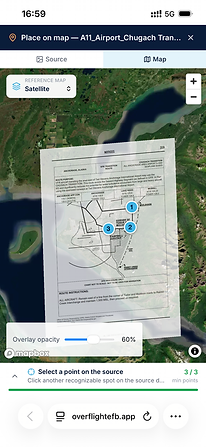
Overflight’s Digital Map Layer Creation tools allow pilots to transform maps, charts, diagrams, imagery, and operational documents into interactive georeferenced layers. Users can import supported PDF and GeoTIFF files as well as simple .png image files, then use reference points to align non-georeferenced documents with real-world locations. Once positioned, layers can be displayed alongside satellite imagery, terrain, FAA charts, airports, obstacles, routes, and custom overlays. Pilots can adjust opacity, remove unwanted backgrounds, show or hide individual layers, and organize imported content within projects. This makes specialized geographic and operational information accessible as reusable digital aviation layers without requiring traditional GIS software.
File Storage & Export System
Overflight’s Intuitive File Storage & Export System provides a centralized workspace for organizing, saving, and managing custom aviation content. A familiar folder and subfolder structure allows pilots to organize waypoints, paths, polygons, map layers, procedures, and other project data by mission, region, aircraft, or operation. Cloud storage keeps saved projects available between sessions and supported devices, while the integrated export system converts organized content into formats compatible with ForeFlight, Garmin Pilot, supported Garmin GPS units, and other applications. This creates a streamlined workflow from creation and organization to storage and export, keeping complex aviation projects accessible and manageable.
Upload Custom Plates to Foreflight
Overflight’s Custom Plate Upload system allows pilots to organize their own PDF aviation documents and prepare them for use as Bring Your Own Plates (BYOP) in ForeFlight. Custom plates can be associated with specific airports and organized into categories such as Airport, Arrivals, Departures, and Approaches. Pilots can upload company procedures, custom diagrams, locally developed information, and other operational documents directly into their projects. When exported as a compatible ForeFlight Content Pack, Overflight automatically organizes supported documents into the appropriate package structure, simplifying the process of bringing customized aviation reference material into the pilot’s existing ForeFlight workflow.
User Waypoint GPS Export System
Overflight’s User Waypoint GPS Export System allows pilots to create, organize, and transfer custom waypoints directly from Overflight into compatible aviation GPS and avionics systems. Pilots can visually place individual waypoints or import large coordinate lists, assign names, organize them into projects, and then export selected waypoint collections using the format required by their equipment. Overflight supports GPX-based exports for compatible Garmin aera devices, such as the aera 660 and 760, and CSV-based waypoint exports for supported Garmin GTN-series navigators, including the GTN 650 and GTN 750. Exported files can be saved directly to the user’s device or shared, greatly simplifying the process of transferring large custom waypoint databases without manually entering each coordinate into the GPS.
Overflight Search/Mass Waypoint Import
Overflight’s Search and Mass Waypoint Import tools make it easy to locate destinations and create large waypoint collections. Pilots can search for airports, geographic locations, coordinates, and other destinations, then quickly navigate to them on the map. For larger projects, Mass Waypoint Import allows structured lists of named latitude and longitude coordinates to be plotted in a single workflow, eliminating repetitive manual waypoint creation. Imported points can be reviewed, renamed, edited, organized, and combined with other overlays. Waypoint collections can then be stored within projects and exported to supported EFBs and compatible aviation GPS systems.
Convert Paths to Programmable Flight Plans
Overflight’s Convert Paths to Programmable Flight Plans feature allows pilots to transform custom paths drawn on the map into structured flight-plan data for use with compatible aviation systems. Pilots can visually design and refine complex routes, then convert the finished geometry into a sequence of programmable flight-plan coordinates that can be exported to a compatible EFB, saved directly to a device, or shared with other pilots and crew members. This is especially useful for survey flights, search patterns, scenic routes, specialized operations, and even complex sky art, where intricate shapes, lettering, or patterns can be designed visually before being transferred to compatible avionics and, where supported, navigation or autopilot systems to assist in flying the planned route.
Create From the Comfort of Your Phone!
Overflight’s Overlay Creator is built to work seamlessly across desktops, laptops, tablets, and mobile phones, giving pilots and operators the flexibility to plan wherever they are. Whether you are building detailed overlays from a desktop workstation or reviewing saved files on the go from an iPhone, Android device, or tablet, Overflight keeps your mission data accessible and easy to manage. Simply save Overflight to your home screen on Apple or Android devices for quick access, allowing you to create, view, organize, and update mission-ready content anytime.




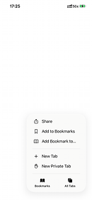


Creating Home Screen Widget
Getting started with Overflight on mobile devices is simple. After visiting the Overflight application in your browser, tap the three-dot menu in the bottom-right corner of the screen, then select “Share.” In the share menu, scroll down and choose “Add to Home Screen.” From there, you can customize the app name before saving it. Once added, Overflight will appear as an app icon on your home screen, giving you fast direct access to your saved files, overlay tools, and mission planning workspace whenever you need it.
What would you like to see?
This is your chance to help shape the future of flight planning. The Overflight Desktop Application is built for pilots, by pilots and your input matters. Tell us what features, tools, or functions you’d like to see in your ideal overlay creator. Whether it’s smarter route tools, new visualization options, or workflow shortcuts, we want to know. Share your ideas below and help us build the most powerful planning platform in aviation.