


Alaska
Safer Skies with less paper charts
The Alaska Chart Supplement overlays by Overflight convert official FAA-published data into clear, visual formats for use on your EFB. This collection includes airport-specific overlays for fields with special procedures, such as Juneau, Fairbanks, Lake Hood, and Ketchikan, displaying remarks, frequencies, and operational details. Every FAA-published VFR transition route is digitally mapped for intuitive visual reference. Anchorage Bowl airspace is highlighted to help distinguish complex Class C and D boundaries, and a CTAF Frequency Area overlay outlines exactly where specific CTAF frequencies apply across uncontrolled airspace. Together, these tools bring the full scope of the Alaska Chart Supplement to life enhancing clarity, reducing cockpit workload, and keeping your situational awareness sharp in all phases of flight.

VFR Transitions
As the centerpiece of our Alaska content, Overflight offers digital overlays of every VFR transition in the FAA Alaska Chart Supplement. Say goodbye to memorizing transitions or carrying paper charts while navigating some of the busiest airspace in the country. Each package includes georeferenced navigation lines, transition waypoints, embedded PDF copies for quick access, route descriptions, and designated altitudes, all seamlessly integrated into your moving map.

PAMR City High Departure

Eastside Overflight

Gravel Pit Arrival

The Campbell Arrival/Departure

CTAF Areas
No more guessing when to switch CTAF frequencies. Our CTAF Areas Package provides clear, seamless boundaries, ensuring each frequency is accurately mapped with bold, precise lines for effortless transitions.

Airport Specific Info
Overflight’s Chart Supplement overlays include detailed, airport-specific information exactly as published by the FAA, covering procedures, remarks, frequencies, and more. Instead of flipping through paper charts or scrolling digital PDFs, users can now access key data directly through ForeFlight’s airport submenu. Associated plates and procedural notes are just a tap away, making critical information easier to find and faster to apply when it matters most.

Part 93/SATR Visualized!
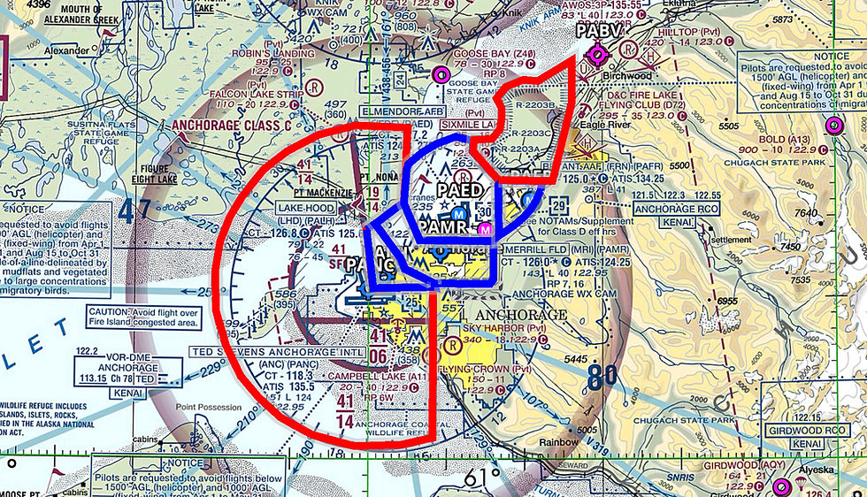
The Anchorage Bowl Part 93 and Special Air Traffic Rules overlay removes the guesswork from operating in one of Alaska’s most complex airspace environments. Instead of eyeballing charts and manually sorting out altitude requirements by zone, pilots can see Part 93 and SATR corridors, altitude limits, and transition areas clearly displayed directly on their moving map. This makes planning arrivals and departures to any Anchorage-area airport faster, more precise, and far less error-prone, especially when navigating weather, traffic, or time constraints in and around Anchorage.
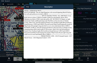
Text Descriptions
Overflight packages incorporate original FAA-published text descriptions like the one shown for critical procedures, routes, and frequencies. These text blocks are embedded directly into each overlay, giving pilots instant access to the same information found in the Alaska Chart Supplement, without needing to flip between sources in-flight. Whether it's departure procedures, altitude restrictions, or ATC frequencies, Overflight ensures all textual guidance is clearly visible and cockpit-ready right on your EFB.

Airspace Highlight
Our Anchorage Bowl Airspace Highlight Tool provides an intuitive way to visualize boundaries within the densely packed airspace of the Anchorage Bowl region, ensuring greater situational awareness for pilots navigating this complex environment.

Intuitive Planning
Overflight waypoints are fully compatible with ForeFlight, allowing pilots to integrate them seamlessly into flight planning. On the flight plan edit screen, each waypoint appears by name, whether part of our official overlay packages or custom content tailored to your specific operation. Simply type the waypoint name, and ForeFlight will snap your route directly to that location. This functionality enhances route building, improves in-flight navigation, and ensures that even personalized Overflight waypoints are just as easy to use as published data.

Experimental PDF Images
Overflight is introducing a powerful new feature: satellite PDF images embedded directly into waypoint overlays. This enhancement gives pilots a real-world visual reference for each location. Mountain passes, lakes, ridgelines, and more, offering added situational awareness beyond chart symbols and descriptions. With just a tap, users can view detailed satellite imagery at any Overflight waypoint, helping with terrain recognition, landmark confirmation, and visual route planning before and during flight. This feature is being rolled out gradually and will soon be available across all major Alaska VFR waypoint packages.

Local Waypoints
Access a clear, detailed overlay of all VFR waypoints published in the FAA Chart Supplement for the state of Alaska. Through extensive in-flight testing, the Overflight team recognized that bold waypoint labels can clutter the moving map display. To improve clarity and usability, we’ve implemented a refined system using translucent waypoint descriptors ensuring essential information remains visible without obstructing your situational awareness.
Alaska Chart Supplement



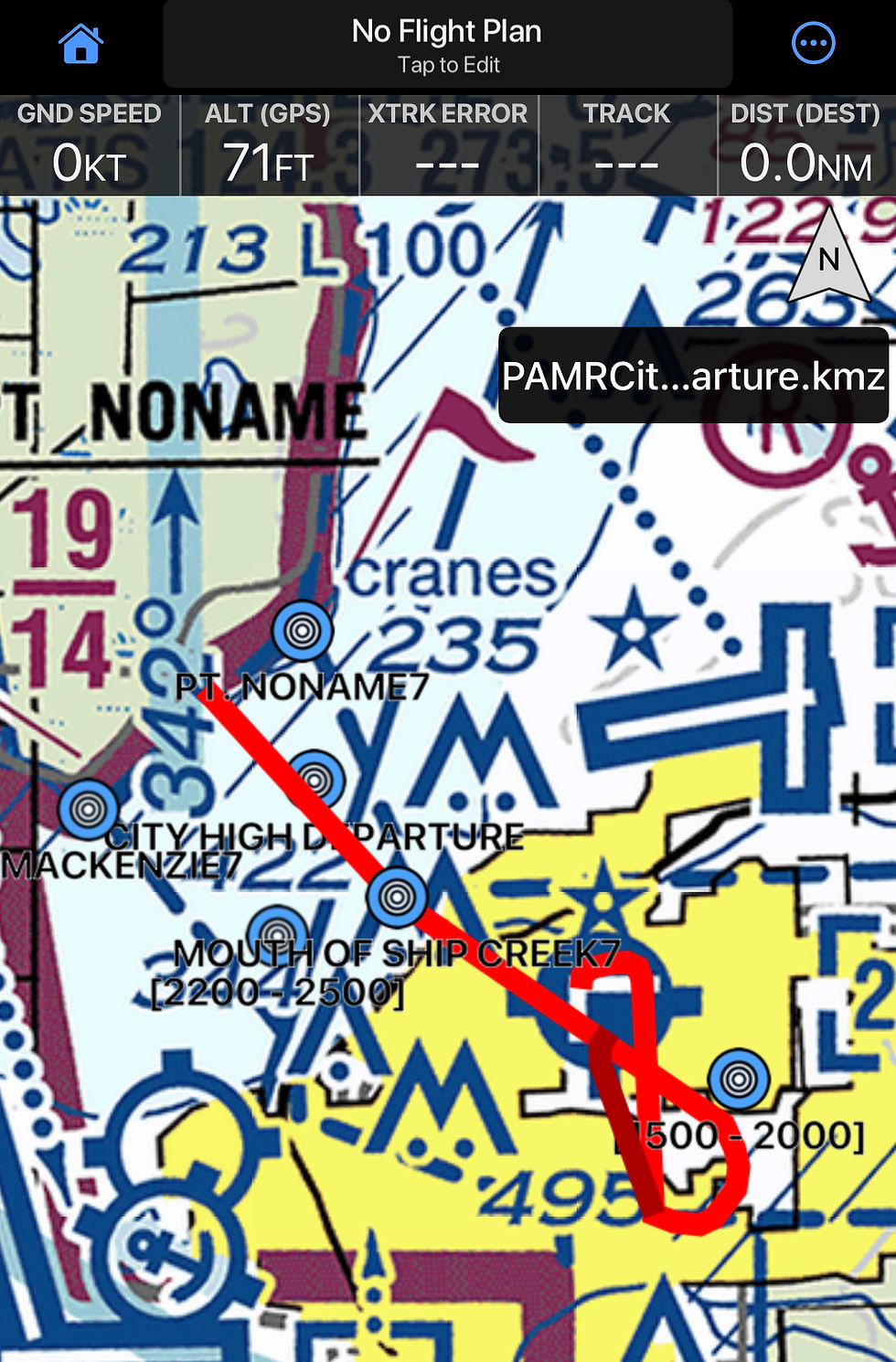


Airports
Each airport package includes digital overlays containing all Alaska Chart Supplement information specific to that airport. This includes VFR transition routes and any other airport specific notes or procedures published in the Chart Supplement, presented in an easy to use visual format for your EFB.
Airports


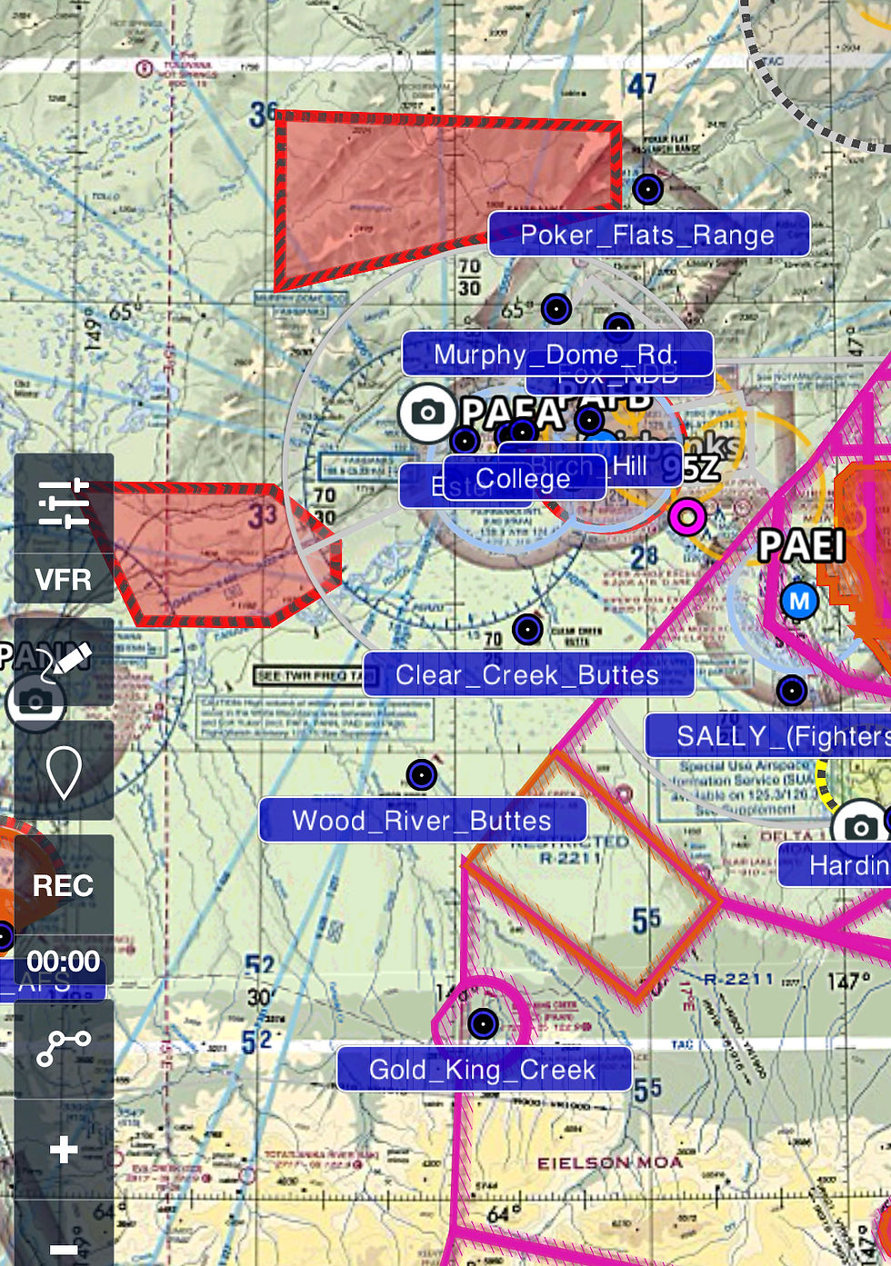
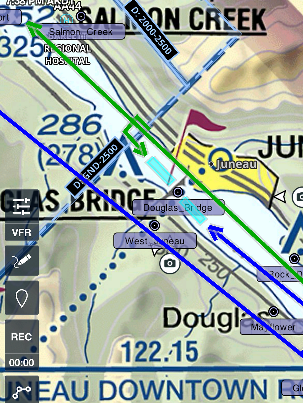

Anchorage Bowl & SATR
These products provide digital overlays of all Anchorage Bowl VFR transition routes and FAA Part 93 Special Air Traffic Rules as published in the Alaska Chart Supplement. Designed for high density airspace, it presents complex routing and restrictions in a clear, EFB ready visual format.
Anchorage Bowl


Additional Content
Beyond the Chart, Built for the Bush
Our additional content provides a growing library of custom EFB overlays designed to improve situational awareness while flying Alaska’s challenging terrain. Unlike FAA Chart Supplement overlays, this content focuses on real world operational information not found in official publications. Current overlays include a color coded Alaska Parks overlay and and all game units. Future additions may include wire strike avoidance data, private lands overlays, and an Alaska Passes overlay with critical terrain and routing notes. Development speed depends on pilot interest, and user feedback is strongly encouraged to guide future content!

Alaska Game Units
The Overflight Alaska Game Units Overlay is now available as part of the Overflight Alaska Package, delivering full statewide coverage with color-coded Game Management Districts and segmented Subunits for instant boundary awareness. Ultimate subscribers also unlock a powerful bonus: an exclusive .GPX waypoint package containing direct entries to every subunit. Simply type the subunit number into your GPS search bar and you’ll be guided straight to the correct location, no extra setup required. Together, these tools give pilots unmatched precision and ease when planning flights and field operations across Alaska.

Alaska Parks System
The Alaska Parks System overlay by Overflight provides a clear, color-coded visual of park boundaries across the state helping pilots identify and navigate around protected areas with ease. Designed to support both in-flight situational awareness and preflight planning, this overlay outlines state and federal parks, preserves, and wildlife refuges directly on your EFB. As part of future updates, Overflight will incorporate downloadable PDFs for each park, featuring detailed regulatory information, recommended flying practices, and relevant ground-use laws. These additions will help pilots not only stay compliant with overflight restrictions but also better understand the environmental and legal considerations when flying near or within Alaska’s protected lands.
Subscribe for the Best Content

The Overflight Alaska Package
Continuously monitors FAA Chart Supplement revisions and integrates changes into both our Chart Supplement overlays and broader Overflight Alaska content as they are published, keeping your EFB accurate, compliant, and flight ready.
With a single subscription, you automatically receive access to all Alaska Chart Supplement materials plus the full Overflight Alaska content library, including any new overlays developed in response to future FAA publications or operational needs. Stay current, save time, and fly smarter with one complete Alaska solution from Overflight.
Add terms and conditions

Overflight Alaska
15
Every month
+$50 Initial Download Fee
Subscribers get full access to all Alaska Chart Supplement and Overflight Alaska content statewide for $50, including .ZIP, .KMZ, and .GPX files. Updates are available through your Overflight account.
Valid until canceled
Complete Alaska Chart Supplement coverage
All Overflight Alaska content included
.KMZ files for Garmin Pilot
.GPX files compatible with cockpit-mounted GPS units
.ZIP bundles for easy organization and bulk downloads
Regular updates as data changes or improves
Access to new material and add-on content as it’s released
Centralized downloads through your Overflight account
Designed for Alaska bush, charter, and backcountry operation
Built to improve situational awareness and flight planning
A11 Fire Island Route
AB SATR Airspace
AB Chugach Transition
AB East Side Overflight
Anchorage Bowl Highlight
AB Powerline Transition
Alaska Coastal Waypoints
Alaska Game Units
Alaska Park Boundaries
CTAF Frequency Grid
Denali Visual Waypoints
KBAY Corridor
Knik Reporting Points
Kuparuk Cooridor
Lake Clark Pass Waypoints
Matsu Valley Waypoints
North Star Island-BP Cooridor
PABE Sierra ArrivalsDeparturesHolds
PAFA Visual Waypoints
PAGYVFR Departure
PAIL07
PAIL17
PAIL25
PAIL35
PAJN Seaplane
PAJN Super Bear Arrival
PAJN Visual Reporting Points
PAKT11
PAKT29
PAKT Visual Waypoints
PALH Chickaloon Departure
PALHEast Route
PALHGravel Pit Arrival
PALHLittle SU Departure
PALHTudor Overpass Arrival Departure
PALHWest Route
PAMR25, 34 & 523
PAMR523
PAMR716
PAMR Campbell ArrivalDeparture
PAMRCARTEE
PAMRChester Creek Departure
PAMRCity High Departure
PAMR Helicopter Routes
PAMRInlet Departure Runway 25
PAMRMuldoon SVFR Arrival Departure
PAMRNONAME SVFR Arrival Departure
PAMRShip Creek Departure
PAMRShoreline Departure Runway 25
PAMRVFR Waypoints
PANCChickaloon Departure
PANCLittle SU Departure
PANCMackenzie Arrival
PANCMidtown Arrival
PANCNorth Shore Departure
PAKT19
Choose your pricing plan
Find one that works for you
Let us know what you'd like to see next!
PO BOX 127
Homer, AK 99603
+1 (907) 756-3837