Foreflight Users
Install, activate, and utilize Overflight content packs in ForeFlight® to enhance safety and situational awareness.
In this video, we’ll guide you through the process of installing and using Overflight content packs within the ForeFlight® app. You’ll learn how to import our packaged .zip files, access individual overlay layers, and enable them directly from your ForeFlight map view. We’ll show you how to use these overlays for route planning, situational awareness, and safer in-flight navigation—highlighting features like VFR waypoints, departure routes, and airspace structure. In addition, we’ll review bonus features supported by ForeFlight’s content pack functionality, including integrated PDF plates, satellite imagery for select waypoints, and direct linking to reference documents—all designed to give you an all-in-one, EFB-ready experience. Whether you’re flying backcountry, coastal, or high-traffic corridors, this video will help you get the most out of your Overflight subscription on ForeFlight.
Foreflight Content


Garmin Pilot Users
Install, activate, and utilize Overflight .KMZ files in Garmin Pilot™ Overlays
In this video, we’ll show you how to install and use Overflight overlays with the Garmin Pilot™ app. Unlike ForeFlight®, Garmin Pilot does not currently support bundled content packs, so each overlay must be individually downloaded and imported as a .KMZ or .KML file. We’ll guide you step-by-step through the process of loading these files into your Garmin Pilot map display and explain how to manage them during flight. Please note that due to platform limitations, certain Overflight features—such as embedded PDF imagery, linked plates for specific waypoints, and interactive content—are not supported within Garmin Pilot. However, you’ll still gain access to our core navigation overlays to enhance your situational awareness and route planning within the Garmin ecosystem.
Garmin Pilot Content


GPS Data Packs
Install Overflight data on cockpit GPS units with simplified functionality—available by extension or individual download.
In this video, we’ll walk you through the process of installing Overflight GPS-specific data packages onto compatible cockpit-mounted navigation units using a direct wired upload. These data packages are designed to provide core navigation support for pilots operating without traditional EFB platforms. However, due to the limitations of many unsupported GPS software systems, certain advanced features may not function as intended. In some cases, waypoint names may not display correctly and could appear in generic formats such as “USER000,” regardless of the original naming conventions used. Additionally, some overlay elements—such as highlighted zones, routes, or linework—may be simplified or omitted entirely, depending on your device’s capabilities. While this method still provides access to essential waypoint and reference data, it is best used as a supplement to the full-featured experience offered through ForeFlight® and Garmin Pilot™. Due to these limitations, GPS-specific data packages will only be available when purchasing our Ultimate, Commercial Packages, or through individual downloads, allowing users to select only what is compatible and relevant for their specific navigation systems.
Add terms and conditions

Overflight Commercial
100
Every month
+$80 Initial Download Fee
Full access to all Overflight content, priority support, monthly custom overlays, and team-wide installs. Ideal for flight schools & operators. Includes .zip, .kmz, and .gpx file formats.
Valid until canceled
All Overflight content included
Formats for ForeFlight, Garmin, GPS
1 custom content request per month
Discount codes for flight students
Priority support & content updates
Team-wide install access
Ideal for flight schools & operators
Monthly updated content packages
Easy distribution across all devices
Access to both Chart & Custom overlays

Overflight Alaska
15
Every month
+$50 Initial Download Fee
Subscribers get full access to all Alaska Chart Supplement and Overflight Alaska content statewide for $50, including .ZIP, .KMZ, and .GPX files. Updates are available through your Overflight account.
Valid until canceled
Complete Alaska Chart Supplement coverage
All Overflight Alaska content included
.KMZ files for Garmin Pilot
.GPX files compatible with cockpit-mounted GPS units
.ZIP bundles for easy organization and bulk downloads
Regular updates as data changes or improves
Access to new material and add-on content as it’s released
Centralized downloads through your Overflight account
Designed for Alaska bush, charter, and backcountry operation
Built to improve situational awareness and flight planning
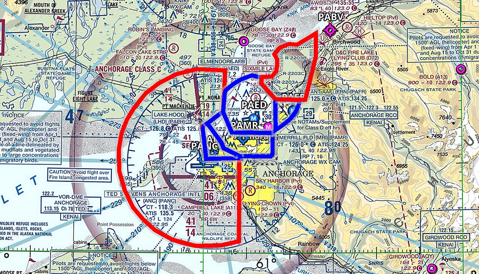
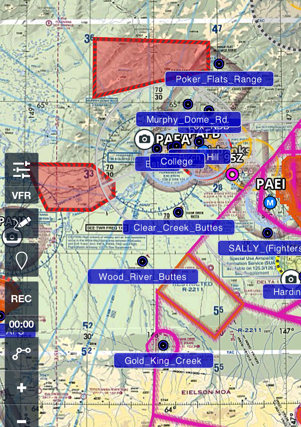
A11 Fire Island Route
AB SATR Airspace
AB Chugach Transition
AB East Side Overflight
Anchorage Bowl Highlight
AB Powerline Transition
Alaska Coastal Waypoints
Alaska Game Units
Alaska Park Boundaries
CTAF Frequency Grid
Denali Visual Waypoints
KBAY Corridor
Knik Reporting Points
Kuparuk Cooridor
Lake Clark Pass Waypoints
Matsu Valley Waypoints
North Star Island-BP Cooridor
PABE Sierra ArrivalsDeparturesHolds
PAFA Visual Waypoints
PAGYVFR Departure
PAIL07
PAIL17
PAIL25
PAIL35
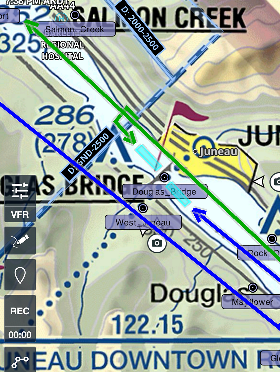
PAJN Seaplane
PAJN Super Bear Arrival
PAJN Visual Reporting Points
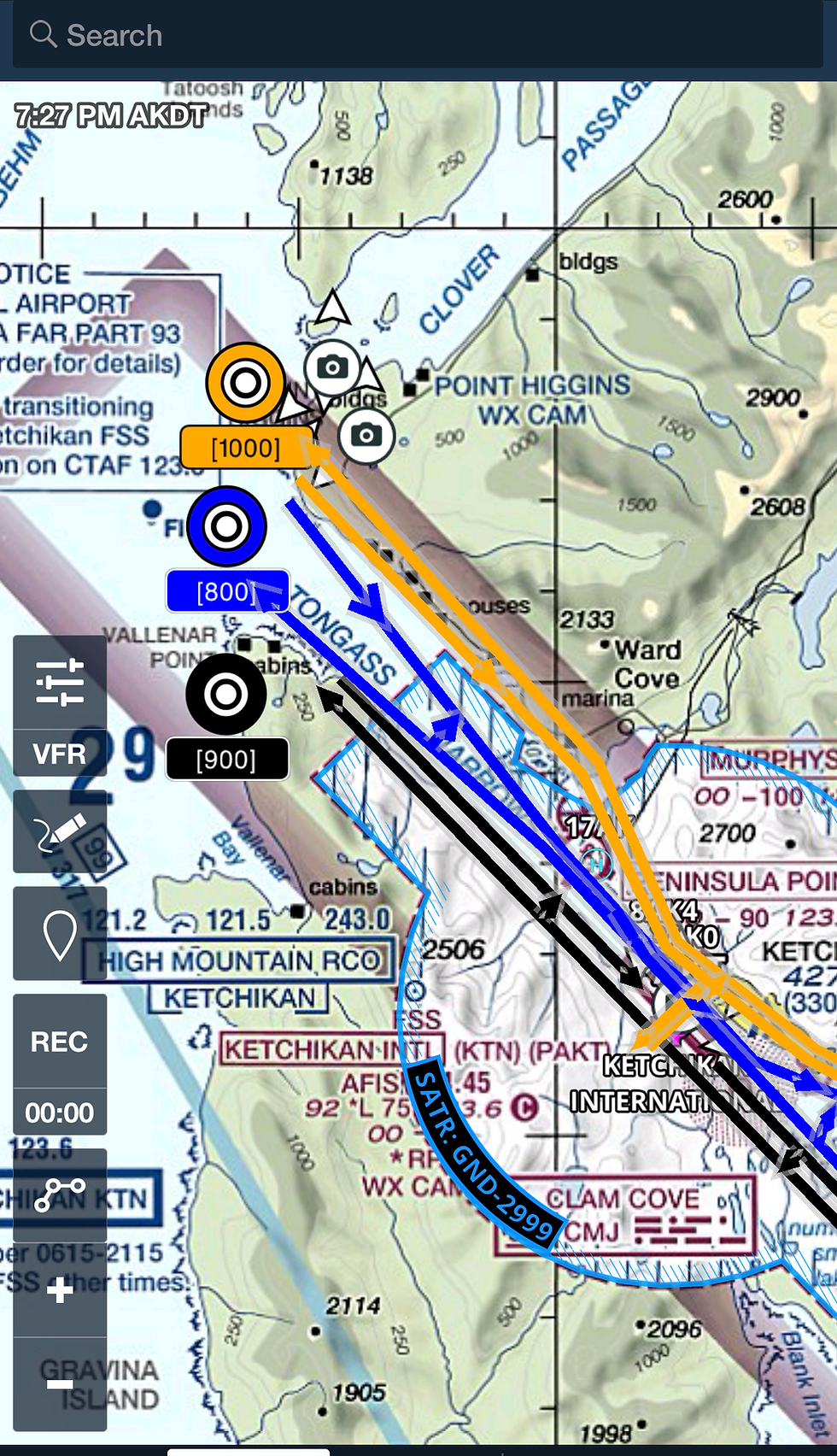
PAKT11
PAKT29
PAKT Visual Waypoints
PALH Chickaloon Departure
PALHEast Route
PALHGravel Pit Arrival
PALHLittle SU Departure
PALHTudor Overpass Arrival Departure
PALHWest Route
PAMR25, 34 & 523
PAMR523
PAMR716
PAMR Campbell ArrivalDeparture
PAMRCARTEE
PAMRChester Creek Departure
PAMRCity High Departure
PAMR Helicopter Routes
PAMRInlet Departure Runway 25
PAMRMuldoon SVFR Arrival Departure
PAMRNONAME SVFR Arrival Departure
PAMRShip Creek Departure
PAMRShoreline Departure Runway 25
PAMRVFR Waypoints
PANCChickaloon Departure
PANCLittle SU Departure
PANCMackenzie Arrival
PANCMidtown Arrival
PANCNorth Shore Departure
PAKT19
Choose your pricing plan
Find one that works for you