
Northeast
Safer Skies with less paper charts
The Northeast Region overlays by Overflight convert official FAA-published data into clear, visual formats for use on your EFB. This collection includes georeferenced VFR Flyway Planning Charts, the Washington DC SFRA and FRZ, and the New York City skyline routes and VFR corridors, all mapped for immediate visual understanding in high-density airspace. Each element is designed to bring structure and clarity to some of the most complex flying environments in the country, helping you quickly interpret routes, boundaries, and operational constraints without digging through multiple references. As the Northeast package continues to expand, new overlays will be developed based on pilot demand, user feedback, and emerging operational needs. Together, these tools bring critical FAA guidance to life, reducing cockpit workload and sharpening situational awareness in every phase of flight.
Georeferenced VFR Planning
The georeferenced VFR Flyway Planning Charts included in the Northeast Region package bring an entirely new level of clarity to flying around major Class Bravo airspace. Designed specifically for seamless use in ForeFlight, these charts are overlaid directly onto your map, allowing you to see recommended VFR routes, transition paths, and altitude guidance exactly where they exist in the real world. In high-density areas like the New York corridor, where airspace is layered, congested, and constantly active, this removes the guesswork from preflight and in-flight decision making. Instead of mentally translating a static chart, you can follow structured pathways around complex airspace with precision and confidence, reducing workload and helping you stay ahead of the airplane in some of the busiest skies in the country.

Baltimore FLY

NY Corridor

NY Skyline
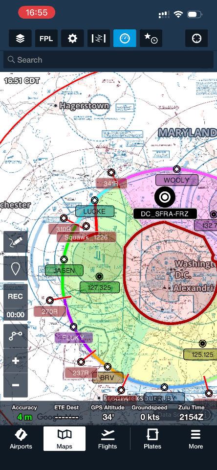
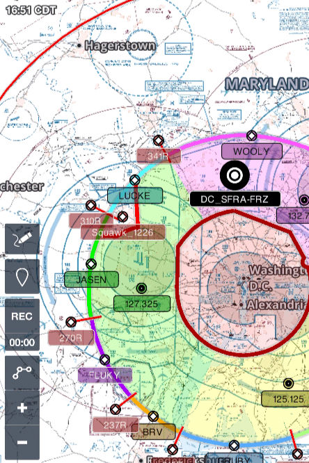
DC SFRA/FRZ Visualized!
The Washington, DC SFRA package by Overflight takes the rules and procedures outlined in the FAA safety course and brings them to life directly on your EFB. Every boundary, gate, and routing requirement is visualized in a clear, intuitive format so you can see exactly how the SFRA and FRZ are structured without relying on memory alone. Available for ForeFlight and Garmin Pilot, this package also includes a dedicated GPX waypoint set that precisely marks each entry gate and the start of its associated lead radial, making navigation into and around the SFRA far more straightforward. The result is a system that turns complex regulatory guidance into something you can actively follow in real time, reducing workload and helping you operate with confidence in one of the most tightly controlled airspace environments in the country.
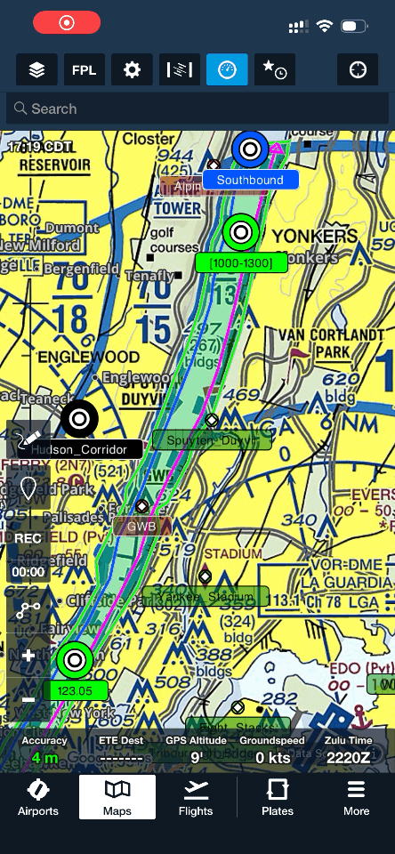
Chart Supplement
The Northeast Chart Supplement overlays by Overflight transform the full scope of FAA Chart Supplement information into high-quality, easy-to-interpret visual overlays for your EFB. Instead of sorting through dense text and scattered references, critical operational details are mapped directly into your flying environment, giving you immediate clarity where it matters most. This package includes detailed visual coverage of the New York VFR Corridor, the Washington DC SFRA, the Niagara Falls area, and the complex helicopter routes around Teterboro, all designed to simplify navigation through some of the busiest and most intricate airspace in the country. By turning static guidance into intuitive visuals, these overlays reduce cockpit workload and help you maintain precise situational awareness from preflight planning through execution.
Quick Access
The integrated quick-access PDFs in the Overflight Northeast package eliminate the need to sift through the Chart Supplement during preflight or in flight. Each overlay includes black-background waypoints that, when tapped in ForeFlight, instantly open associated procedure documents. Instead of searching through pages of text, the information you need is tied directly to its location on the map, allowing access in seconds. This creates a seamless link between visual overlays and official documentation, reducing workload and keeping critical procedures exactly where you need them. This feature is currently supported in ForeFlight only.

Northeast Chart Supplement


Subscribe for the Best Content

The Overflight Northeast Package
The Overflight Northeast package is built to give you everything you need to operate confidently in some of the most complex airspace in the country, all in one place. Your purchase includes full access to every overlay currently in the package, from georeferenced VFR planning charts to corridor routes, SFRA structures, and region-specific procedures, all formatted for seamless use on your preferred EFB. By subscribing, you ensure that your content stays current with ongoing updates and improvements, while also gaining access to any new overlays and features Overflight continues to develop for the region. As the Northeast package grows based on real pilot demand and operational needs, your toolkit evolves with it, keeping your situational awareness sharp and your planning process streamlined.
Add terms and conditions
Overflight Northeast
10
Every month
+$35 Initial Download Fee
Overflight Northeast delivers precision overlays from Chart Supplement data, plus custom content for NYC, DC SFRA, VFR planning, and more to simplify complex airspace and boost awareness.
Valid until canceled
NY Skyline VFR Planning chart
NY Corridor VFR Planning chart
Baltimore VFR Planning Chart
DC SFRA/FRZ Overlay
NY Corridor Overlay
Niagara Falls Area Overlay
Teterboro Helicopters Routes Overlay
Constantly up to date content
More to come!
Choose your pricing plan
Find one that works for you
Let us know what you'd like to see next!
PO BOX 127
Homer, AK 99603
+1 (907) 756-3837